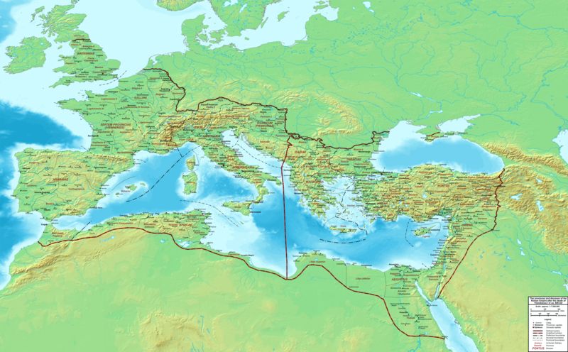
File:The Roman Empire ca 400 AD.png

Original file (4,339 × 2,689 pixels, file size: 12.8 MB, MIME type: image/png)
Captions
Captions
Summary[edit]

|
This file has been superseded by The Roman Empire ca. 400 AD.svg. It is recommended to use the other file. Please note that deleting superseded images requires consent.
|

|
| DescriptionThe Roman Empire ca 400 AD.png | Map of the Roman Empire ca. 400 AD, showing the administrative division into dioceses and provinces, as well as the major cities. The demarcation between Eastern and Western Empires is noted in red. | |||
| Date | ||||
| Source |
Base map found at User:Koba-chan/Topographic map, otherwise self-made. Data based on maps in atlases (Westermann's Atlas zur Weltgeschichte, the Academy of Athens' History of the Greek Nation, etc.) and the internet and on contemporary sources, primarily the Notitia Dignitatum and the Synecdemus. |
|||
| Author | Cplakidas | |||
| Other versions |
|
Licensing[edit]
| Public domainPublic domainfalsefalse |
| I, the copyright holder of this work, release this work into the public domain. This applies worldwide. In some countries this may not be legally possible; if so: I grant anyone the right to use this work for any purpose, without any conditions, unless such conditions are required by law. |
| Annotations InfoField | This image is annotated: View the annotations at Commons |
As noted in the file description, the location or even existence of the various British provinces is a matter of uncertainty and debate. The current placement should be taken as purely indicative.
File history
Click on a date/time to view the file as it appeared at that time.
| Date/Time | Thumbnail | Dimensions | User | Comment | |
|---|---|---|---|---|---|
| current | 22:27, 19 February 2015 |  | 4,339 × 2,689 (12.8 MB) | Cplakidas (talk | contribs) | added potential location of Valentia beyond Hadrian's Wall, removed provincial boundaries in Britannia as too tentative |
| 13:03, 21 July 2011 |  | 4,339 × 2,689 (10.9 MB) | Cplakidas (talk | contribs) | fixed Persian border, differentiated between Eastern and Western empire, different borders for praet. prefectures | |
| 02:37, 21 March 2009 |  | 4,475 × 2,600 (9.99 MB) | Cplakidas (talk | contribs) | minor corrections | |
| 12:30, 29 May 2008 |  | 3,800 × 2,370 (8.1 MB) | Cplakidas (talk | contribs) | ||
| 12:17, 29 May 2008 |  | 4,560 × 2,850 (11.22 MB) | Cplakidas (talk | contribs) | clearer version & addition of the Armenian satrapies | |
| 02:02, 30 December 2007 |  | 3,380 × 2,120 (5.96 MB) | Cplakidas (talk | contribs) | added names of dioceses, legend box, various minor adjustments | |
| 14:27, 13 December 2007 |  | 3,550 × 2,200 (6.65 MB) | Cplakidas (talk | contribs) | new improved version made with Inkscape, slight corrections in borders, added several cities in Africa & Spain | |
| 19:27, 12 November 2007 |  | 3,550 × 2,200 (4.75 MB) | Cplakidas (talk | contribs) | minor corrections in southern Gaul | |
| 12:58, 5 November 2007 |  | 3,550 × 2,200 (4.75 MB) | Cplakidas (talk | contribs) | New version, with some corrections & additions | |
| 16:55, 31 October 2007 |  | 3,436 × 2,142 (4.5 MB) | Cplakidas (talk | contribs) | {{Information |Description=Map of the Roman Empire ca. 400 AD, showing the administrative division into dioceses and provinces, as well as the major cities. The demarcation between Eastern and Western Empires is noted in red. |Source=Base map found at |
You cannot overwrite this file.
File usage on Commons
The following 16 pages use this file:
- Atlas of the Middle Ages
- User:Cplakidas
- User:Eduardogobi/Favorites
- File:Diocese of Africa - AD 400.png
- File:Diocese of Macedonia - AD 400.png
- File:Illyricum & Dacia - AD 400.png
- File:Italia Annonaria ca 400 AD.png
- File:Macedonia ad400.png
- File:Moesia - AD 400.png
- File:Roman Britain - AD 400.png
- File:Roman Gaul - AD 400.png
- File:Roman Italy - AD 400.png
- File:Roman Spain - AD 400.png
- File:The Roman Empire ca 400 AD (Danube provinces).png
- File:Tripolitania within the Diocese of Africa - AD 400 (cropped).png
- File:Ufernoricum & Binnenoricum - AD 400.png
File usage on other wikis
The following other wikis use this file:
- Usage on af.wikipedia.org
- Usage on ar.wikipedia.org
- Usage on ary.wikipedia.org
- Usage on ast.wikipedia.org
- Usage on bg.wikipedia.org
- Usage on bn.wikipedia.org
- Usage on ca.wikipedia.org
- Usage on ceb.wikipedia.org
- Usage on cs.wikipedia.org
- Usage on de.wikipedia.org
- Usage on el.wikipedia.org
- Usage on en.wikipedia.org
- Usage on eo.wikipedia.org
- Usage on es.wikipedia.org
- Usage on et.wikipedia.org
- Usage on fr.wikipedia.org
- Usage on he.wikipedia.org
- Usage on hi.wikipedia.org
- Usage on hr.wikipedia.org
- Usage on hu.wikipedia.org
- Usage on id.wikipedia.org
- Usage on it.wikipedia.org
- Usage on ko.wikipedia.org
- Usage on la.wikipedia.org
- Usage on lt.wikipedia.org
- Usage on nl.wikipedia.org
View more global usage of this file.
Metadata
This file contains additional information such as Exif metadata which may have been added by the digital camera, scanner, or software program used to create or digitize it. If the file has been modified from its original state, some details such as the timestamp may not fully reflect those of the original file. The timestamp is only as accurate as the clock in the camera, and it may be completely wrong.
| Horizontal resolution | 43.31 dpc |
|---|---|
| Vertical resolution | 43.31 dpc |
| Software used |
.png/128px-The_Roman_Empire_ca_400_AD_(Danube_provinces).png)
